The right to the city is an evolving concept. Currently, it is related to accessibility, inclusion, sustainability and safety in cities; design is a tool that can help to apply them. This article recounts my journey in the Mexico City subway, to demonstrate precisely how design can create accessible spaces and destinations within the reach of all people, regardless of language, age or physical condition.
“We share the ideal of a city for all, referring to equality in the use and enjoyment of cities and human settlements and seeking to promote inclusiveness and to ensure that all inhabitants, both present and future generations, without discrimination of any kind, can create just, safe, healthy, accessible, affordable, resilient and sustainable cities and human settlements and dwell in them (…)”
(New Urban Agenda by ONU Habitat, 11th principle)
The right to the city as a philosophy is more than 50 years old. It was proposed by Henri Lefebvre, a French intellectual, follower of Marx, Hegel and Nietzsche, whose work focused on the critique of society and the search for new forms of political and social organization (Purcell, 2014).
In his book “Le droit à la ville“, Lefebvre put forward an idea opposed to the industrial and capitalist cities that were growing rapidly in the 1960s. He suggested a social reconstruction, where the urban space could be occupied by all the people who live in the city, because as inhabitants they are also owners of that space.
For Lefebvre, then, the “right to the city” consisted fundamentally in guaranteeing the “right to urban life”, to fill the space in which you live with flows, relationships and experiences. In short, the right to appropriate the city and to build it collectively from everyday life and social and cultural practices.
Right to the city as a human right
Lefebvre’s philosophy has a social conception of the city. If translated into physical space, it can be understood as the fight against private property and the creation of public space:squares, parks and places for people. Under this approach, and linked to human rights, a new concept of the right to the city has emerged, promoted by the UN.
Published in 2016, in the New Urban Agenda, the right to the city aims to make the communities in which we live fairer, safer and more accessible to all people. It aligns with the SDGs (Sustainable Development Goals), specifically SDG 11 (Sustainable Cities and Communities), and states the following:
Integrates locals, foreigners, indigenous and minority groups, creating an inclusive citizenship;
Promotes political participation for decision making, both by government and civil society;
Fulfills its social functions, i.e., provides access to housing, goods and services to its entire population;
It has quality public spaces and services;
Stimulates the creation of diverse and inclusive economies;
Creates healthy urban-rural linkages, where the environment and natural resources are respected.
Mobility within the right to the city
A large part of the concept of right to the city has to do with people’s access to public services and spaces. The way in which we move around cities and reach these spaces is a key factor in the construction of the right to the city.
Among the various modes of transport, public transport is a democratic and equitable option. The UN has set as a goal for 2030, “to provide access to safe, affordable, accessible and sustainable transport systems for all and to improve road safety, including through the expansion of public transport“.
This mode of transportation represents an advantage over the automobile, as it can move a larger number of people in a single trip (reducing pollution and road congestion).
According to the Deloitte City Mobility Index from 2019, 25% of people in Paris use public transport for their daily commute. Also, in the United States, it is a means that has increased its use by 28% from 1995 to 2018. In countries such as Mexico, 50.9% of the population uses it (INEGI, 2017), as it is a cheaper option than the car.
Design and accessibility
A means of transport so widely used in cities must offer quality to its users. Some indicators to measure it are those proposed by the ITDP (Institute for Transportation and Development Policy, 2017) in its Transport Oriented Development (TOD) Standard:
Public transport must have accessible, barrier-free, and safe stations for the entire population;
A maximum distance of 1.0 km between stations is recommended, and from buildings such as schools, hospitals, or apartments;
Buses or trains should circulate at least every 5 minutes, with a schedule from 7:00 to 22:00 hours, and guarantee coverage in all areas of a city;
Finally, it is desirable that they connect with other modes of transport, such as bicycles, pedestrian zones, or public transport of different types.
These features speak to the external aspects of the system. However, navigation within it is an equally important part of getting from one place to another, and this is where design plays a key role. Imagine you are a child, a foreigner or a person who cannot read, and you need to get somewhere using the subway. An efficient public transport network would allow you to do so intuitively. And design has the power to create it.
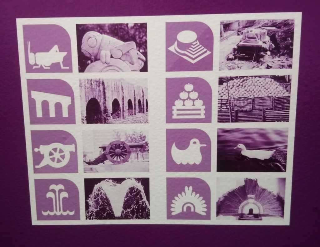
Design principles for navigating the public transportation system. Mexico City’s subway
References for the design of station logos (Urbanauth /SVI / 2019)
Mexico City’s Collective Transportation System (Metro) is an emblematic means of transportation that is almost 52 years old. Built in September 1969, being the seventh in the world, it currently has 195 stations distributed in 12 lines, which moves 5.5 million people daily.
It is a 226-kilometer network that reaches all cardinal points of the city, so having a simple and easy-to-follow navigation system is an essential requirement for its operation. The designer in charge of creating the entire graphic image of the subway was the North American Lance Wyman, who also designed the logo for the 1968 Olympic Games.
The project had the objective of orienting the user within the system. Wyman designed the entire signage, including typographies, indications and symbols for each station, taking for the names geographical, cultural or historical reference of the place. This resulted in a graphic identity that is still in force today, and has become a key element in the image of Mexico City.
Navigating the Mexico City subway
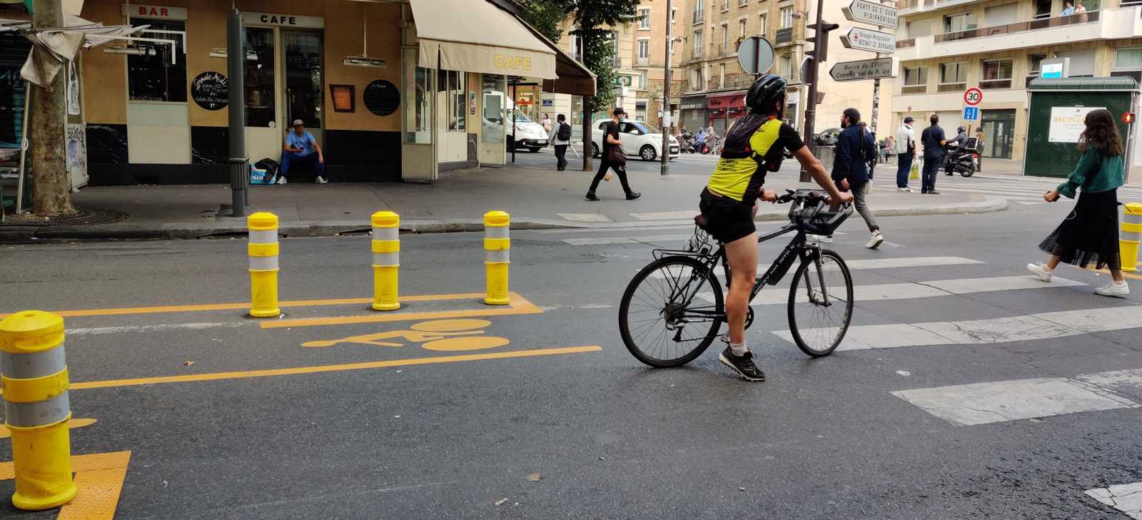
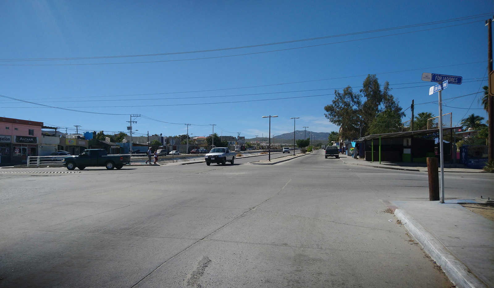
With the premise of testing the subway signaling system, I traveled through 16 stations on 5 different lines. The hypothesis was that the system provides enough information for someone to travel within it, change lines and go to the right direction. My expedition was based on a few questions, from which I found the following answers:
Are subway stations easily identifiable from the street?
Station sign; entrance from the street (Urbanauth/ SVI / 2021)
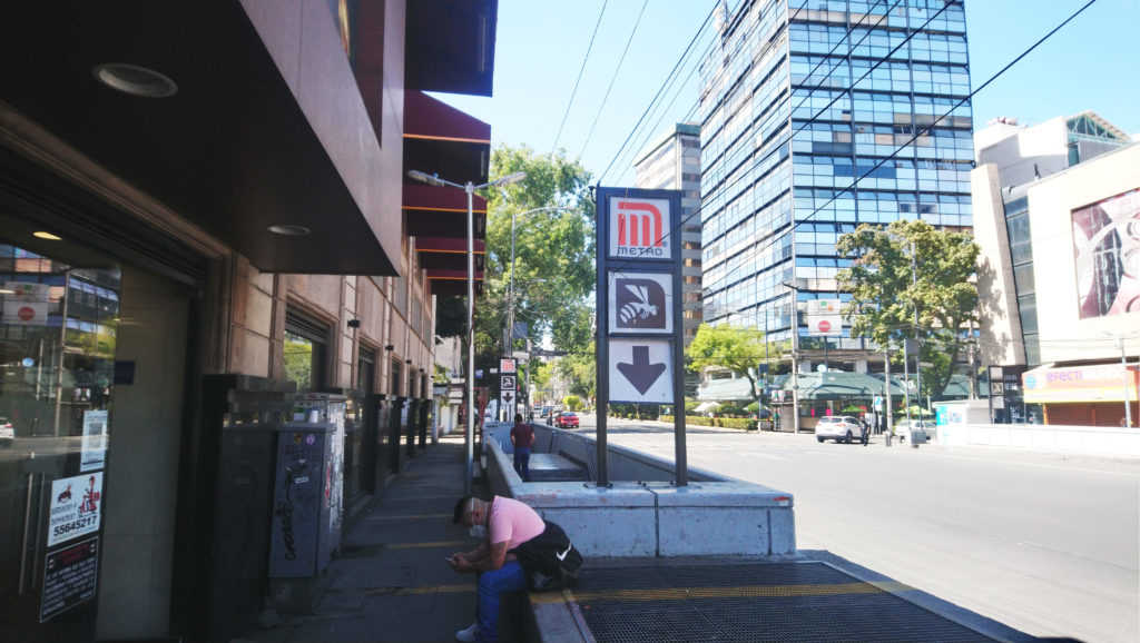
The signage outside Mexico City’s subway stations is visible. It consists of a sign that shows, in the first place, the Metro logo, indicating the type of transport it is. Secondly, the station logo appears, with the color of the line. Each of the 12 lines has a different color. Thirdly, an arrow points to where the station is located. As you approach the station door, another sign also shows the number of the line, along with the written name of the station.
Up to this point, the system is based on three types of language: written, colors and symbols (logo, numbers and arrows). In this way, people who cannot read can find options to identify the stations. For now, the course has been clear.
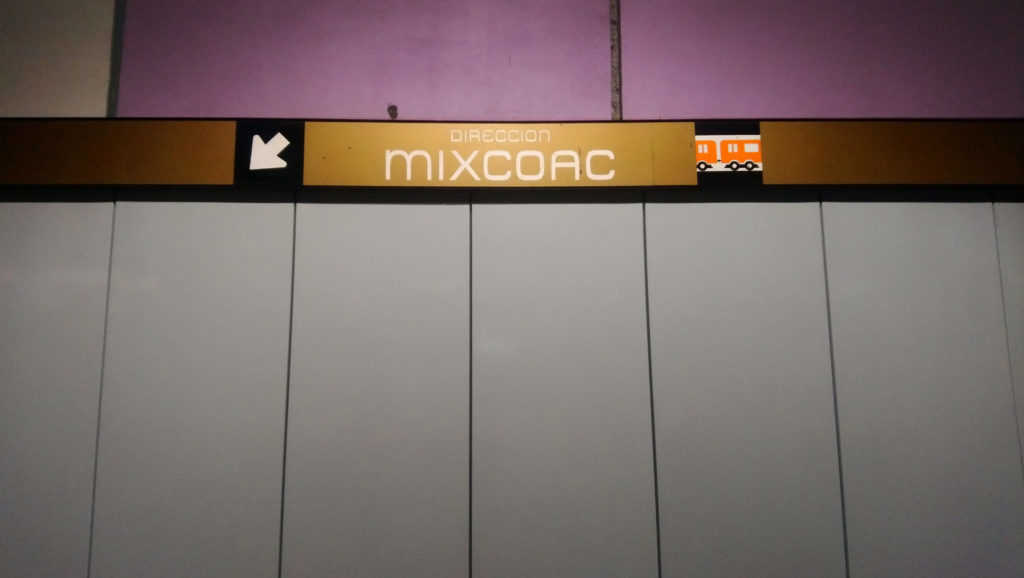
Is navigation inside the station easy?
Platform directional signs. They point out the name of the destination station; they omit logos (Urbanauth/ SVI / 2021)
When inside a station, you can identify three types of signage:
Circulation signs: Signal entrances and exits, as well as directions on the platforms;
Context signs: They can be location maps (neighborhood scale), maps of the entire network and list of stations on the line.
Services: They point to the ticket office, stores and internet centers.
Context and service signage in the metro is clear. It is based on recognizable icons, such as people climbing stairs, arrows or no trespassing signs. These are universal symbols. In addition, the station name and logo are repeated on several walls, so you always know where you are.
However, there is a problem with the platform addresses. While the name of the destination station (with its color) is indicated on each platform, the logo is not included. This is a disadvantage for people who cannot read or speak the language, as it will be difficult to understand which direction the platform trains travel.
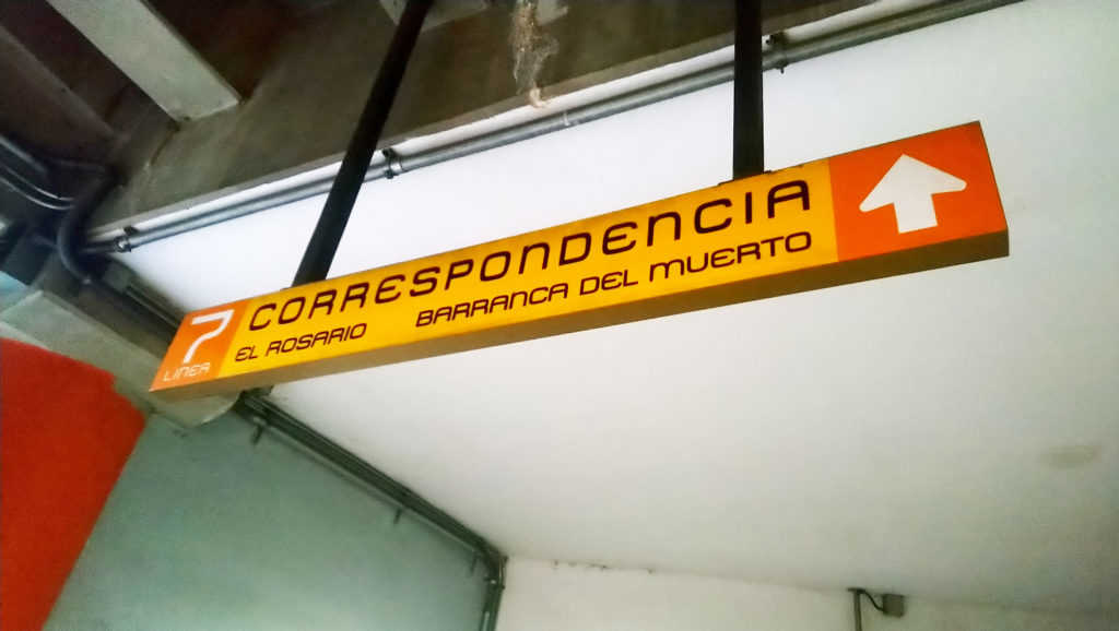
Are the line crossings clear?
Correspondence (crossing lines) sign (Urbanauth/ SVI / 2021)
The sufficiency of network maps at stations provides a lot of information about the directions people should take. There are several maps within the station, as well as listings of next and previous stations; in this way, people can identify crossings between lines.
However, like the directional signs on the platforms, the line crossings omit the use of logos. Line crossing signs follow a clear design: they are yellow rectangular signs, accompanied by a white letter C (Correspondence). They include a line in the color of the line to which the station connects, and an arrow indicating the direction. They are apparently simple to understand, and are visible at any point along the route.
The omission of the logo, again, makes them difficult to understand for people who cannot read or speak the language. These people would have to be guided by the arrows, arrive at the platform and observe the identification sign on it. These do contain the logo, but if the person made a mistake, they would have to turn around and go to the opposite platform.
What information is available about the environment surrounding the station?
About the context outside the station, two types of information are provided: points of interest and other modes of transportation.
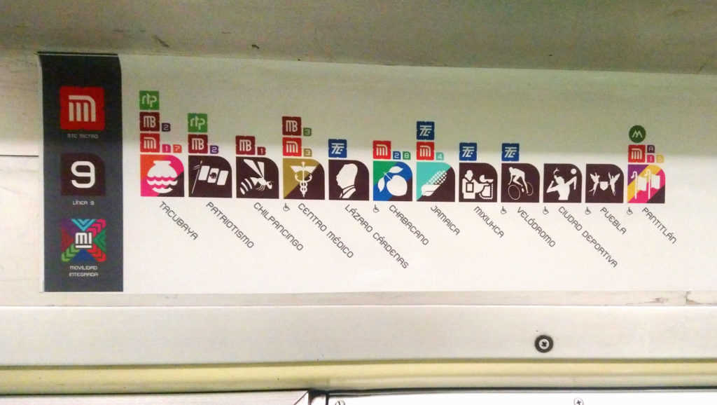
The points of interest are shown through neighborhood level maps containing basic iconography, such as banks, hospitals and schools, accompanied by the station logo, so they are clear in general.
As for modes of transport, a diagram is used showing all the stations of the line with their logo. Above each logo, symbols of other transportation systems are added, as well as a number indicating which line of that transportation it is (and which color). This is a great advantage, since it allows people to plan their trips according to the information they know exists outside.
Diagram showing connections with other means of transport (Urbanauth/2021)
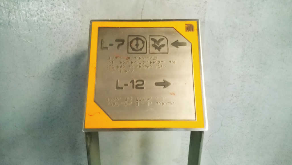
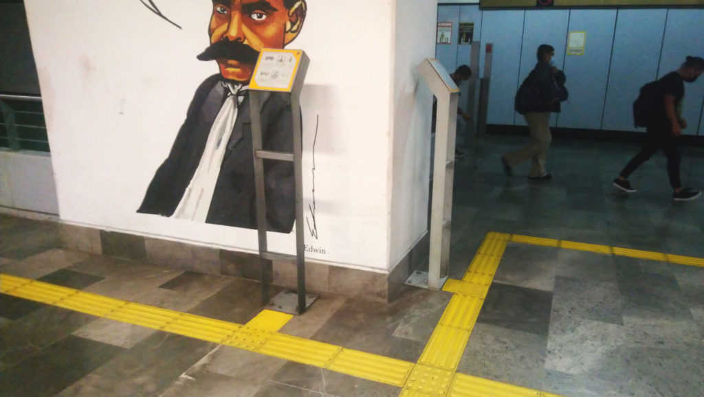
Can a blind person move freely within the system?
The efficiency of a transportation system is really put to the test when it attempts to serve people with disabilities. If it is functional for them, it is an inclusive system, and it is functional for everyone.
In the case of the Mexico City subway, there are some good practices that have been implemented over time in station refurbishments.
Currently, there are metal plaques with Braille language, containing station logos and directional arrows. These plaques are connected to the station entrance by means of tactile guides. The guides also direct to the elevators and safety lines on the platforms. These elements represent a big step towards inclusive public transport, but there are still many stations that are not accessible.
Metal plaques with Braille language (Urbanauth/ SVI /2021)Connection of the plates with podotactile guides in yellow (Urbanauth/ SVI / 2021)
Lessons and conclusions
My trip through the Mexico City subway left me with a series of reflections. I have condensed them to formulate these design principles:
An efficient and inclusive public transportation signaling system:
Uses a universal language, based on shapes, colors or symbols that are recognizable to all people;
Uses simple typographies, with simple geometries; in contrasting colors and visible sizes;
Provides information in all its spaces and corridors; it becomes a resource to reach your destination without setbacks;
Provides information about its context, because it knows that it is not an isolated element of the city;
Knows that children are also traveling in it, so it uses signs at different heights and very eye-catching;
Think of all your users, regardless of the language they speak or the capabilities they have;
Protects people and creates safe routes for all, regardless of age, gender, ethnicity, or physical condition;
And, lastly, it creates spaces where people feel free and independent.
Give it a try. Take a ride on public transportation and see if you can ride it freely. I did it in Mexico City but you can do it anywhere. Let’s think about those for whom it is not so easy. Let’s help to build little by little the right to the city.
Urban Heat Islands are on the rise. In the summer of 2003, Europe suffered a heat wave that reached historic temperatures. From June to mid-August, from northern Spain to the Czech Republic, and from Germany to Italy, temperatures rose 20 to 30% above the average for this season – reaching up to 40°C.
According to Britannica, this wave, produced by an anticyclone (a phenomenon that prevented rain), caused the death of 30,000 people throughout the continent: more than 14,000 in France.
However, in 2007 a significant difference was reported, compared to the 2003 figure; 19,490 deaths in France, with heat-related causes. This represents an increase in deaths of almost 30% in four years.
This phenomenon called attention to the effects of climate change, and the consequences of high temperatures for the population in cities. It raised an alarm about the concentration of heat in urban areas and made visible the deficiencies that exist in dealing with heat islands.
What are Urban Heat Islands?
An Urban Heat Island (UHI) is an urban region where temperatures are higher than in the surrounding rural areas. It is generated mainly in large and densely populated cities, with a lack of green spaces. The concentration of human activities, transportation and electrical energy used in buildings and homes produce heat that bounces off surfaces such as concrete, causing the heat island effect. It can occur on various scales, from as tiny as a neighborhood to as big as a metropolitan area.
Why do Urban Heat Islands exist?
The main factors that cause heat islands are the following:
The endless city. Paris is a good example for a strongly urbanized landscape. Thus giving birth to urban heat islands which are a direct result of the impact of urbanism on urban climate. (Urbanauth / 2020)
Insufficient green or natural areas in cities, such as trees, vegetation, rivers, or water bodies. These function as absorbers of the heat propagated by transport or electrical energy, in addition to contributing to the purification of the air.
Excessive use of construction materials Intrinsic to their specific attributes, construction materials have an impact on the urban climate. On the one hand, this concerns reflective materials such as glass and steel, which make heat bounce off and saturate the outside environment. On the other hand, there are asphalt and concrete, which temporarily store heat and then return it to their surroundings. This is in contrast to green spaces and water surfaces, which absorb heat.
The shape of the city: the link between urban planning and climate change is recent. The impact that zoning can have on the natural environment is impressive. A city with few open areas, or with tall buildings close to each other, designed without thinking on a human scale, will block the passage of wind and concentrate heat. (United States Environmental Protection Agency)
Human activities that involve the use of motor vehicles, air conditioning or electrical power. Industry is one of the activities that generates the highest percentage of polluting gases and increase of temperatures.
What are the impacts of Urban Heat Islands in correlation with high temperatures for cities?
Increased energy consumption, which is also a cause. At higher temperatures, more use of air conditioning or travel in closed vehicles, which in turn produce more heat.
Damage to health: high temperatures during the day can cause respiratory diseases, cramps, tiredness and even heart attacks. At night, the heat affects people’s rest, generating stress (Pan American Health Organization). For example, in the Mexican city of Mexicali, 81 temperature-related deaths were recorded during the first 15 days of June 2019. This city reaches up to 50 °C in summer, where the elderly, children and people in poverty are the most vulnerable.
Damage on water quality, which in turn alters the metabolic, reproductive, and feeding processes of marine species living in hot water bodies
Alterations to the wildlife: their food may be reduced, their places of refuge may be destroyed or burned, causing them to seek new territories and modifying the ecosystems.
How can we cool down cities? Green infrastructure and water may be solutions. (Urbanauth / 2020)
How can we cool down cities?
Following the deaths caused by the 2003 heat wave, Paris set a goal of planting 20,000 new trees by 2020. By 2015, about 62 hectares of natural areas and 4.7 hectares of green roofs had been built. By 2020, an additional 100 hectares of green roofs will be created, which will also serve as urban gardens.
In addition, the city has a Climate Action Plan, where it establishes objectives and actions to reduce temperatures and increase its resilience. The Plan includes incentives for citizens to plant more trees in the streets and public space, creating greener communities.
In Stuttgart, Germany, a Climate Atlas was created in 2008 for 179 villages in the region. In this planning instrument, actions were proposed to counteract the risks derived from the effects of climate change. This area is in a valley with significant automotive activity that has caused concentration of greenhouse gases and high temperatures. Included in this Atlas is the Climate Booklet for Urban Development, which dictates guidelines to ensure that cities have green corridors surrounded by vegetation, and where topography is taken advantage of to use the dominant winds.
In New York, a simpler measure was used. In 2010, approximately 1,600 volunteers worked on nearly 1 million square meters of rooftop area, in an initiative called New York Cool Roofs. Promoted by the city government, the initiative consists of painting the roofs in white, to reflect the heat and avoid it indoors, reducing the use of air conditioning. This measure saves approximately 2,282 tons of CO2 per year.
Ecodistrict in Paris: mixed-use development, which integrates vegetation and energy efficiency and sustainability practices. (Urbanauth / 2020)
Green infrastructure
Other measures applicable in cities are known as green infrastructure. Green roofs and vegetation are part of it. This is a type of infrastructure that uses natural systems to improve environmental quality, also benefiting the cultural, economic, and social sectors.
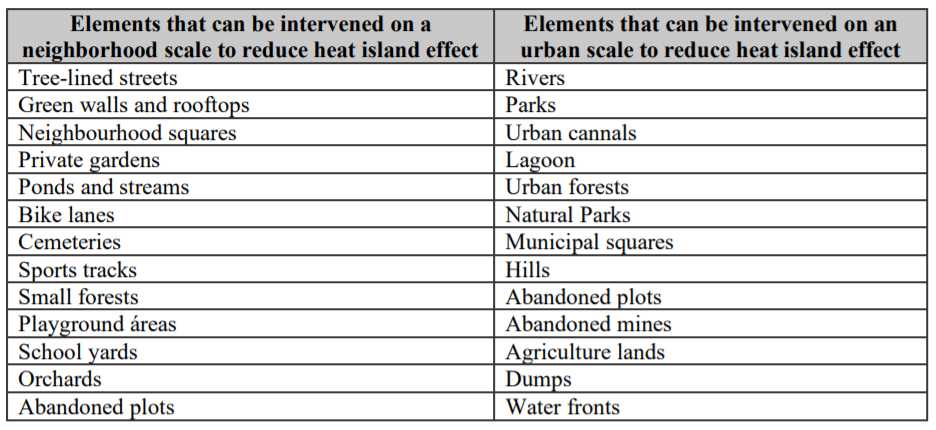
The following table shows a list of elements that can be included, increased, or intervened in cities, to reduce the heat island effect and recover the environment:
Based on the “Green Infrastructure Design Guide for Mexican Municipalities” by the Municipal Planning Institute of Hermosillo (2017)
Some last thoughts
Climate change is one of the crises we are facing. Its effects accentuate or allow us to see practices that have been developed in the wrong way, and the integral planning of cities acquires even more importance to protect people’s lives. Citizen participation and multidisciplinary vision are components that must be prioritized in urban design, to understand the contexts and the real needs of a landscape. Cities must cease to exist in series, without planning and without nature, as they become risk areas impossible to inhabit.
It is impossible to study the city from a single perspective; the contribution of several disciplines is necessary to arrive at an understanding of the different aspects of urban reality (Lamy, 2019).
The origin of civilization goes back to the time when people decided to settle down and live as a group. These communities were places of exchange where people found stability. They took their form following the rhythms of nature, the cycle of life and their spiritual beliefs.
Today, those forms of living are long gone. According to the UN, in 2050 two-thirds of the world-population will live in cities. The beliefs and activities of these people have changed, and therefore their way of making community. Especially on the African and Asian continents, cities are growing at an accelerated rate. The so-called mega-cities are facing great challenges related to transport systems, affordable living spaces and climate change. Future-oriented planning-processes are urgent.
Urbanism is the discipline in charge of studying, planning and consolidating cities. Its objective is to raise people’s quality of life through infrastructure and equipment. For its success, it must have a holistic vision. It can combine sociology, economics, politics, law, technology, architecture, design, and in recent decades, sustainability and the environment.
Urbanism and urbanization
It is important to define the differences between two concepts that are often confused: urbanism and urbanization. The first one refers to an analytical, research and planning process. The second one means city development.
Although it is possible that there is urbanism without urbanization, urbanization without urbanism generates chaos. A clear example of this are the irregular settlements in Latin American cities. They have suffered accelerated growth since the 1950s, due to migration from the countryside to the city. However, high housing prices caused people to settle far from urban centers, with no order or regulation.
One such settlement is Ecatepec in Mexico. It currently has more than 1.6 million inhabitants living in precarious conditions of overcrowding, lack of infrastructure (like streetlights or sidewalks), parks and green areas. These conditions have contributed to making Ecatepec the city with the highest perception of insecurity in the country.
Because of its proximity to Mexico City and the road infrastructure that began to be built in the 1940s, people from other states in Mexico migrated to Ecatepec. Its growth was stimulated by the ease of buying land; however, it was urbanization without planning.
Today, Ecatepec is the most populated municipality in the country. There is a high level of poverty and unemployment. People work in the industrial sector, and their jobs are unstable with long hours. It is a place of violence, assaults, kidnapping and femicide.
Another example of unplanned urbanization is the favelas in Brazil. These emerged as homes in the mountains surrounding Rio de Janeiro. People built them with cheap materials, due to the scarcity of housing in the city. Today, they are an icon of the South American country. However, they are places of drug trafficking and crime.
Urbanism and urban design
Urban design is a discipline closely related to urban planning, but it involves tangible and more specific actions. Urban design deals with the treatment of space that is used directly by people in the city. It integrates disciplines such as architecture and landscape architecture, which focus on the design of squares, bus stops, parks, or gardens. It aims to provide the user with a comfortable experience in the street and public space.
Nowadays, urban design is concerned with including aspects of universal accessibility, such as ramps for people with disabilities, footprints, and traffic lights with sound. In addition, it tries to create an inclusive, intuitive space focused on pedestrians. For that, streets have features to reduce vehicle speeds and to promote other modes of transportation such as bicycles or public transport.
Another approach that designers use in urban design is the gender perspective. Public spaces that integrate this criteria contain elements that improve safety and comfort conditions for women, such as:
Pedestrian lighting
Clear sidewalks with no obstructions to visibility
Floor textures that do not make it difficult to walk in heels
Public bathrooms
Furniture at bus stops for wheelbarrows or heavy loads
Sociological urban studies
The objective of urbanism, beyond the understanding of a city, is the execution of policies or actions for its improvement. Still, to formulate these actions, it is necessary to understand urban dynamics. This is:
The importance of space in the interaction of people and,
The way in which space configures their actions (and vice versa). Defining space as a man-made and natural environment, and also the one that is established through communication.
Urban studies in sociology have been linked to architecture and urban planning. However, in the last 10 to 20 years, sociologists have focused on subjects like:
The types of spaces and cities
The flow of information between and within them
How foreigners shape the space
The development of small communities and their connection to large cities
Stratification and infrastructure between cities
Mobility patterns and the use of public space.
These topics are valuable to city planners since the success of their strategies depends on their understanding.
New Urbanism
City planners have adopted a new approach to making cities. It opposes the ideas of horizontal expansion, division of cities into zones and the need for cars. In the New Urbanism, the city is for the people and should be designed on a human scale, taking into consideration the following principles:
Walkability: The streets are pedestrian friendly and have the necessary infrastructure to move around comfortably. In addition, places such as schools, shops, hospitals or restaurants are within a 10-minute walk from homes or work.
Connectivity: The structure of the streets, avenues and boulevards of the city is designed in such a way that traffic flows. Also, any point of the city can be reached efficiently
Mixed-use and diversity: Neighborhoods contain various types of buildings and businesses, mixed with houses that are inhabited by people of various ages, sex and socioeconomic levels
Mixed housing: Housing of different sizes, types and prices in the same area
Architecture and urban design: Focused on comfort and on providing the user with a pleasant experience in public space. It gives great importance to aesthetics and vegetation
High density: Vertical housing is preferred over horizontal growth of the city, as it means shorter commutes and lower expending on infrastructure
Green transport: Support is given to non-motorized or mass transport such as trains, buses, bicycles or scooters
Sustainability: Environmentally friendly practices such as water and energy saving, consumption of local products and reduction of motor vehicles.
Smart Growth
The principles in New Urbanism derive in the concept of Smart Growth. A city that grows smartly has diverse benefits for people, like better quality of life, greater amount of businesses and opportunities for investors or real estate. Within the Smart Growth concept, there are many models of community building. One of them are the TOD’s (Transit Oriented Developments). They search to provide people with the same opportunities to move to any point in the city, through diverse, accessible, economical, low environmental impact and resilient modes of transport.
To achieve their objective, a TOD follows the principles of:
Walking: safe and accessible pedestrian environment
Pedaling: safe cyclist network
Connecting: short and direct pedestrian / cyclist routes
Transporting: high quality public transportation that is accessible by walking
Mixing: services at a short distance from home or work. Also, public space is active for several hours
Densifying: places with a high concentration of housing and work have quality services
Compacting: new developments are in consolidated urban areas, not in the periphery
Related to the TOD, there is the Walk-Up model. They are neighborhoods designed to be accessible on foot. To this end, they improve their infrastructure for pedestrians and mix land uses so that people can find everything in their path. A Walk-Up can be a TOD that contributes with the principles of Walking, Connecting and Mixing.
Urbanism and climate change
Cities have a key role to play in combating the effects of climate change. They generate more than 60% of energy consumption, 70% of greenhouse gas emissions, and 75% of carbon emissions (https://www.un.org/sustainabledevelopment/cities/). All these cause alterations in the climate that reflect in hurricanes, floods, fires, droughts or loss of biodiversity. Local governments must begin to develop urban projects or policies based on this scenario.
In the fight against climate change, there are two types of action: mitigation and adaptation. The former focuses on reducing gas emissions, energy consumption, water consumption or the generation of waste resulting from human activities. Adaptation measures aim to reduce the effects that natural phenomena have on cities. That is, to reduce their vulnerability to floods, landslides or high temperatures.
One mitigation measure that has proved effective is the establishment of Low Emission Zones (LEZ). These are areas that restrict the passage of vehicles according to their gas emissions. A common criterion is to prohibit the transit of older vehicles or trucks that, in theory, pollute more than more recent vehicles. There is also a ban on diesel vehicles.
On the other hand, a measure for adapting to the effects of climate change can be the creation of new green areas and planting trees in the city. These actions reduce temperatures and help the absorption of rainwater, which avoids the risk of flooding.
For the success of mitigation or adaptation projects, a sustainability component must be considered. It refers to actions in favor of the economic, social and environmental satisfaction of a community, without reducing the possibilities of future generations to take care of their needs.
For closing
Urbanism, as a discipline that seeks to improve people’s lives in community, is much more than study and analysis. It is a reflection of several rapidly changing forms of life and must therefore cooperate with increasingly complex sciences and philosophies. It must achieve an integral vision in order to understand people’s needs and to provide solutions. Humans shape cities but cities can also shape their lives, directing them to fulfillment.
Water stress is a global phenomenon and affects cities in Europe as well as in Asia, Africa or America. According to the UN, more than 3 billion people around the world are suffering from water-related problems, since the amount of water per inhabitant has been reduced by a fifth in the last 20 years.
For example Mexico City’s water source is repeatedly affected by droughts. Consequently the government of the city, home to more than 21 million people, announced in mid-2019 a suspension of the water supply in some neighborhoods. However, this is a common situation for the more than 200 thousand people who do not even have a connection to the hydraulic network. In a city that annually suffers from flooding and which has got a leaking network of pipes, water management is the priority.
Water in the cities
According to the UN, 55% of today’s population live in cities; by 2050, this number will approximately increase by 13%, and their demand for water will rise by 40% by 2030.
To address the challenges of urban growth and climate change the UN has proposed 17 international goals, which countries committed to meet by 2030. They are called the Sustainable Development Goals (SDG’s), and they are a worldwide effort to improve social, environmental and economic conditions.
Within the SDG’s, Goal 11 refers specifically to sustainable cities and communities. Certainly, their development includes a vision of environment, energy efficiency, quality of life, equity and inclusion. Related to Goal 11, one of the main challenges for urban planners is water management, both domestic and drainage systems.
Cape Town (South Africa), which is possibly the first city to run out of water due to drought
Moscow (Russia), which has the largest water reserve in the world – but it is polluted by industrial activities
London (UK), which has to take water from the Thames and Lea rivers; or
Tokyo (Japan), whose supply comes mainly from finite sources such as rivers, lakes and melting snow (US News)
Harare (Zimbabwe), where droughts also affect crops and food resources in a society of extreme poverty (The Guardian)
Diverse cities in the U.S., where there is a shortage of piped water supply, and this is uneven. Households of color are 35% more likely than white households not to have piped water (The Guardian)
Some of these cities have already begun to take action to prevent the water crisis. For example, the Isla Urbana project in Mexico City, a rainwater harvesting system that can serve a family for up to 8 months. The project started in 2009, with the objective of giving access to water to the neighborhoods in Mexico City that suffer frequent interruptions in supply. Since then, they have installed 19 thousand units and have collected more than 700 million liters of rainwater, benefiting approximately 114 thousand people (islaurbana.org/english/)
Another example is Rotterdam, which, although it does not experience water shortages, has flooding problems. In 2013, they built Benthemplein, which is a “rainwater square” composed of three esplanades that sit below street level. In this way, Benthemplein retains rainwater, preventing it from flooding the urban area and overloading the sewers. Moreover it also functions as a public space on days when it does not rain (www.c40.org)
What else can resolve waterstress related issues?
It is important to start taking action now, through strategies, policies, systems and infrastructure that contribute to the preservation of the vital liquid and the quality of life. Tokyo, for example, is investing in its network of pipes to reduce waste; in the United States, water gardens have been designed, which are green areas that retain the rain accumulated on the streets or roofs and filter it into the ground.
Multiple actions can be carried out, such as awareness campaigns in schools or public places, incentives to reduce our water consumption, or even planting trees. To get the idea of the topic there are tools like the Climate Adaption App. In short this is a catalogue of climate change adaptation actions that can be very useful for urban planners, designers and society as well. Moreover we can also participate in the strategies to face the urban water crisis.
Have you ever imagined what Oxford Street would look like if it were only for pedestrians? Have you ever seen a neglected spot in your city that could turn into a park? Or can you imagine a road that is no longer dangerous for people in wheelchairs? There is a quick, efficient and low-cost way to test these ideas. People call it tactical urbanism.
What is tactical urbanism?
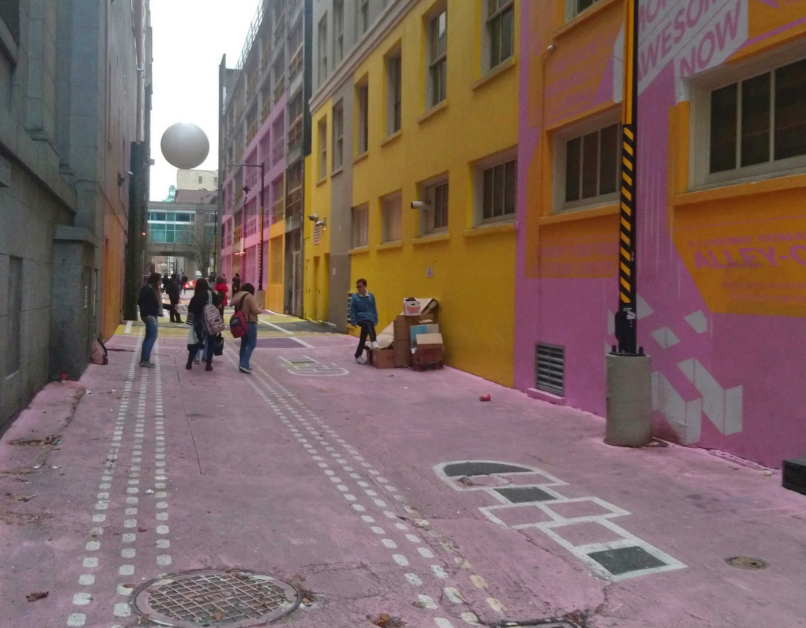
Also known as urban acupuncture, DIY urbanism, or planning-by-doing, tactical urbanism has been a popular practice for the last ten years in cities in Europe, the United States and Latin America. It is more successful in comparsion to traditional urban planning because of several factors. One of them is the relative technical and operational ease of implementation. Another key to success of tactical urbanism are the findings about urban dynamics it provides. Undoubtedly these findings include a real understanding of the needs of the population, the collection of reliable data directly from the site and collaboration between different actors in a community. So tactical urbanism can have a particularly efficient impact due to favoring of permanent changes from temporary interventions.
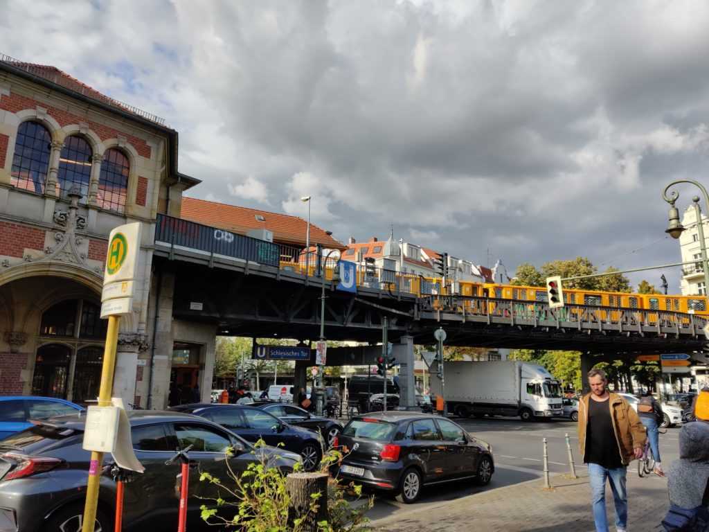
Cars waiting at the traffic light – Berlin “Schlesisches Tor” (Urbanauth / 2019)
Success stories
Labplatz (Berlin, Germany)
In Berlin, in July 2012, the BMW Guggenheim Lab organized a tactical urbanism test (www.thisbigcity.net) that consisted in the elimination of parking spaces to be used as recreation areas. The project was called “Labplatz” and sought to make people think about the way public space is currently set up. With different materials and elements, such as chalk, inflatable swimming pools and children’s furniture, the inhabitants of Berlin appropriated the spaces currently occupied by automobiles.
Symbolic picture under unsplash license, by Brianna Santellan.
Broadway (New York)
In September 2019, the StreetopiaUWS collective of New York’s Upper West Side enabled people to take a walk on Broadway. Consequently the collective placed tables and chairs between 73rd and 79th streets on the -usually busy with traffic- Broadway. StreetopiaUWS organizers closed the way for vehicles, giving New Yorkers the opportunity to make their own a space they mostly share with cars. Altogether StreetopiaUWS hopes that the New York Department of Transportation will be able to realize the results of the test. Undoubtedly the action aims to cause the city proposing strategies that make streets more pedestrian-friendly.
Lane shared by pedestrians, cyclists and cars. Symbolic picture under unsplash license, by Jil Beckmann.
Panama Walks (City of Panama)
Latin American cities have experienced accelerated growth since the 1950s due to rural-urban migrations. This, together with a model of city thought for the vehicle, has generated chaos in the streets, where people compete for the use of space with private vehicles and public transportation. Thereupon, in 2018, the Municipality of Panama, along with the Inter-American Development Bank, carried out the “Panama Camina” Project (Panama Walks, source: www.iadb.org), with the purpose of recovering the historic center and returning it to people, to create belonging and identity. To this end, an intervention was organized in Plaza Cinco de Mayo, where the pedestrian space was delimited with paint. This allowed cultural and social activities to take place, in an area where it is usually difficult to do so.
The cities of Latin America have been developed with a model based on the use of the automobile. Symbolic picture under unsplash license, by Milo Miloezger.
What do I need to do a tactical urbanism test?
First, a need must be identified. So go out and walk your street, your neighborhood or your city. Also talk to people and listen to their stories, asking yourself if getting around is easy; and if the sidewalks allow all kinds of people to move, or if a child or an elderly person can walk in the streets without risk. Once a need has been found, a clear vision of what is wanted for the street should be built. Besides this, goals must be defined, and a team of professionals, government officials and community people must be formed to work on them.
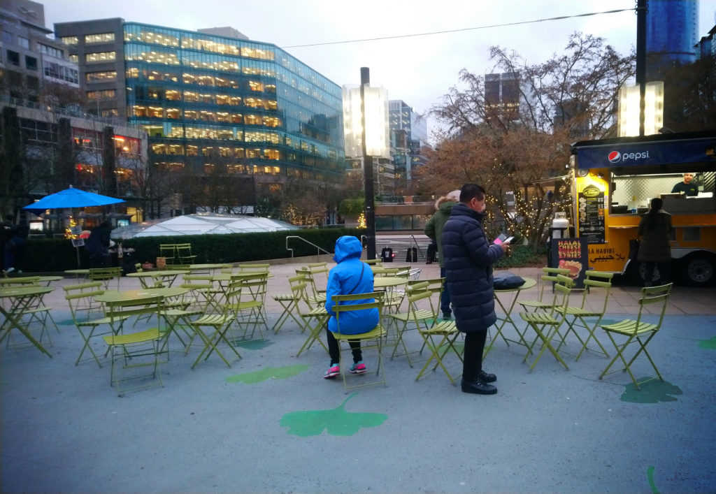
Food area made with paint and common furniture in Vancouver, Canada (Urbanauth / 2019)
The success of a tactical urbanism test will depend, mainly, on the understanding of a place and the people who inhabit it. As well as the teamwork, and the creativity to use all available resources according to one objective: to make cities participatory spaces that are more livable for everyone.
This article is also available in german and french.